
Can you price a bike lane into car insurance? I tried.
A rabbit-hole into whether protected cycling infrastructure is priced into insurance.
I was first drawn to this topic by the apparently obvious claim that protected bycicle infrastructure should have positive effects on pedestrian fatalities, and general road deaths. Many of the claims floating around assert perfunctorily that more protected bicycle lanes and more bike-friendly integrated infrastructure reduce the incidence and severity of motor vehicle accidents on roads. However, once considering other effects such as the higher urbanisation rates and the interchange of cause and effect of bikeways, the effect becomes way more opaque, given that the places which are most liable to have bicycle infrastructure should also be the places most dangerous on the whole.
So then I raised the simple question, that if protected bike lanes cut crashes, does any insurer price that? When I couldn't find an existing model, I asked: is it worth it for insurer to price it in? In this case, post code may act as a sufficient proxy.
Controlling for these effects and the kind of infrastructure (paint), we do observe that protected bicycle infrastructure reduces road fatalities, but that the postcode already capture almost all of the severity signal, and would be redundant. Where you live plays a sufficient role for insurers to not consider asking.
Does the model exist? No.
I triangulated this three ways: a broad literature sweep, full-text reads of the key papers, and a systematic census of Scopus (the largest abstract database).
No published model prices cycling-infrastructure quality into a premium, not in auto, bicycle, or health/life insurance.
The closest near-miss (Alfonso-Sánchez et al., 2026) puts road-network density features into a motor claim-frequency model and gets a 19% out-of-sample improvement, then stops one step short of a premium.
So I tried to build it
Ah, Toronto. Doug Ford with his anti-cyclist messages and the tear-down of bicycle infrastructure in Canada, serves as the perfect dataset for my exploratory calculation.
Toronto, because its open Cycling Network dataset carries an INSTALLED year for every segment, which gives us a natural interventionary experiment. The ingredients of the stamppot, all open data:
- 1,581 cycling-network segments (install year + infrastructure type + geometry)
- 12,804 cyclist-involved collisions, all severities, 2014–2026, geocoded
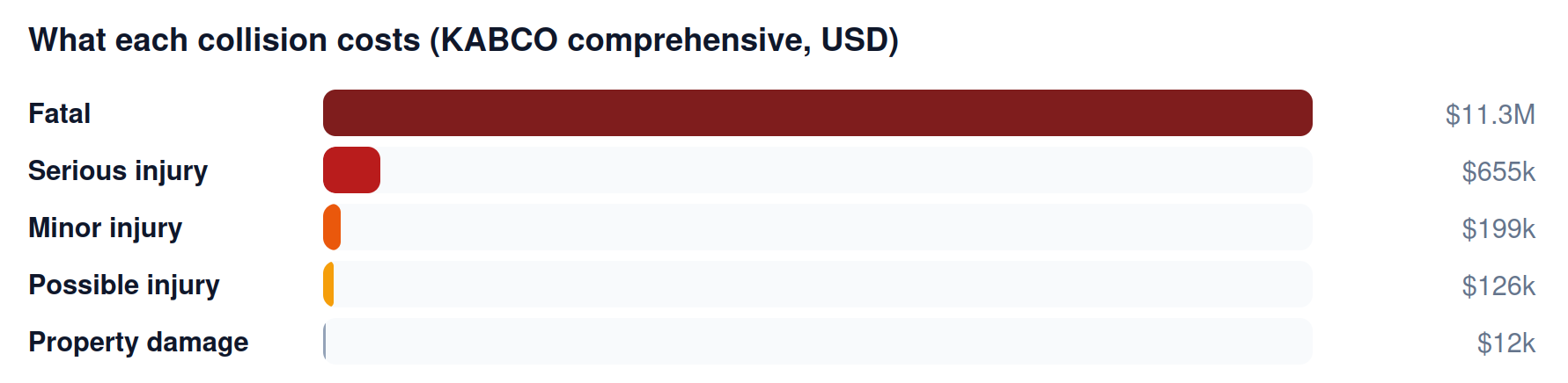
- US KABCO crash-cost tables to put dollars on severity
The results
The robust signals:
- City-wide, per-rider serious-injury risk fell ~62% over the network buildout decade (2010–12 vs 2018–22), while raw counts fell only ~36%. The denominator was hiding half the gain: ridership roughly doubled, so per-cyclist risk dropped far more than the headline counts suggest.
- Collisions became less severe near new infrastructure. The injurious share of cyclist collisions fell 80% to 66% at protected lanes (−14 points, highly significant) and 78% to 61% at painted lanes. This is a ratio within collisions, and matches the engineering literature: separation prevents the worst crashes.
- Put dollars on that shift and you get a real number: expected cost per cyclist collision falls ~17% on protected-lane segments (a "severity relativity" of 0.83), and it's robust at −17% to −18% no matter how you cost the injury tier.
The cautionary tale (and the most interesting bit):
- The naive frequency intervention calculation says protected lanes are followed by +47% more collisions.
Adjust for city-wide ridership: still +32%. We then run empirical Bayes to strip out regression-to-mean and background trend: the effect grows to +61%.
We find that a new cycle track surges ridership on that street ~2.5×, while a city-wide adjustment only removes ~1.2×. More cyclists means more (minor) collisions, even as each cyclist gets safer. The point of running EB was to rule out the statistical explanations, and it did. With regression-to-mean and trend gone, the only thing left is exposure. The frequency effect is unrecoverable by better statistics; it's a data gap, not a method gap. You need local cyclist counts, which Toronto doesn't openly publish.
Here's the thing the severity number above doesn't settle. Territory (postcode) rating already absorbs realised infrastructure through average loss experience. So the real question was never "does infrastructure affect severity?" It's "is there infrastructure signal left after you condition on the postcode?" If there isn't, a dedicated factor is redundant no matter how real the effect.
I ran that decomposition directly: injurious-or-not per collision, with and without territory fixed effects, at the FSA scale Ontario auto insurers would use. On its own, sitting at a built protected lane lowers the injurious share about 2.8 points (statistically significant). Add postcode fixed effects and that effect collapses to roughly zero, and stays near zero across spatial scales. The signal is almost entirely between postcodes (about 10 points of injurious-share per unit of protected-lane share), which is exactly the slice territory rating already prices.
How can this be reasonable? Because protected lanes get built on busy arterials that start above average severity. The lane pulls them down a lot, but only to roughly the city average. So a static map of "where the lanes are" tells the postcode almost nothing it didn't already know.
So we find that, unfortunately, standalone infrastructure severity rating factor is largely redundant with territory rating. What survives is temporal, not cross-sectional. Territory rating only sees the 14-point drop three to five years later, as losses emerge; an infrastructure-keyed model could see it the day the lane opens. Responsiveness and thin-data postcodes are the prize, not a new static signal.
That is, if bicycle infrastructure is being built nearby, you should expect a small drop in your premiums since insurers only see the benefit a few years later.
If you were an insurer for health
Don't build a standalone "bike-lane" rating factor. Regulatorily exotic, proxy-discrimination risk, and territory rating already captures it.
Lead with responsiveness, not a static map. The cross-sectional severity level already lives in your territory experience; what that experience can't do is react when a lane opens. Track infrastructure changes and reprice promptly, using the before/after severity drop as the prior.
Blend it into territory relativities with credibility. The value over plain loss-experience rating is responsiveness (reprice when a lane opens, not 3–5 years later) and thin-data postcodes.
If protected lanes cut your cyclist-claim severity ~17%, lobbying a city to build them is cheaper than absorbing the claims.
Why it stays unbuilt
Here's the real answer to the original question. Territory rating already absorbs realised infrastructure through loss experience, so the marginal value of an explicit model is just responsiveness and thin-data lift (real but modest) set against a non-trivial regulatory and discrimination cost.
You cannot compute the frequency half without proprietary exposure, and that exact gap is why insurers fall back on postcodes in the first place.
Everything runs on open data: Toronto Open Data, Toronto Police collision records, and the Transportation Tomorrow Survey. Numbers are a proof-of-concept, not an insurer-grade model.